Annual Hydrotechnical Hazard Monitoring:
High-Order River Crossing Integrity
Executive Summary
Primary Objective: To provide high-quality and high-precision Depth of Cover (DOC) information, ensuring asset integrity through advanced sub-surface mapping and bathymetric fusion.
- Clients: Pembina, Enbridge, TransCanada, ATCO, Plains, TransNorthern
- Location: Various watercourses across Canada.
- Leaders: Andrew Healy, P.Eng., ALS and Elviss Laicans

Identifying Submerged Threats to Asset Integrity
Watercourse crossings are the most volatile segments of a pipeline network, where invisible riverbed changes can lead to failure.
The Problem
Dynamic Erosion
Technical Constraints
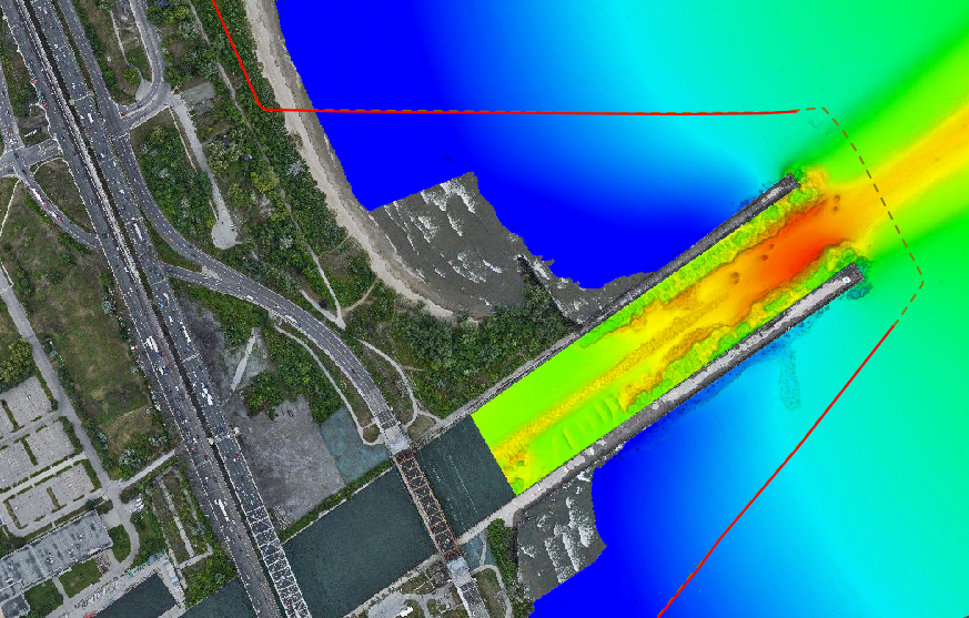
High-Resolution Hazard Detection
MSI utilizes a rigorous “Dual-Link” verification process to ensure the underwater surface and the pipeline’s position are geodetically absolute.
Echo Sounding Fusion
MSI deploys a strategic combination of Multibeam (MBES) and Singlebeam (SBES) echosounding technologies. This fusion allows us to capture high-density 3D morphological data in open reaches while maintaining the versatility to survey shallow, high-clutter, or restricted environments where traditional topographic methods may be limited.
Specialized Swift Water Operations
Our reputation is built on the caliber of our field teams. MSI crews are highly trained and Swift Water Certified, possessing the professional comfort and technical skill required to operate safely and precisely around any body of water—from calm reservoirs to high-velocity mountain river systems.
High-Density Surface Mapping
Delivering over 100 pts/m2 provides the resolution necessary to distinguish between natural riverbed features and hazardous debris.
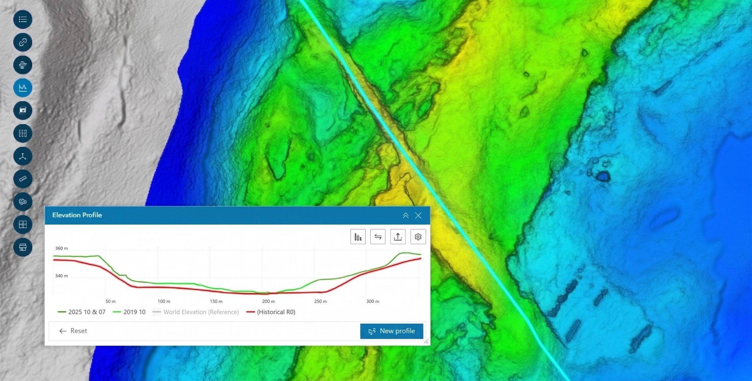
Bathymetric Change Detection
MSI utilizes a customized in-house algorithm on point cloud data. This allows for precise point-to-point tracking of riverbed changes between survey epochs, identifying subtle scour patterns and sediment migration that standard surface-to-surface modeling misses.
Sub-Bottom Profiling (SBP) Integration
To remove the guesswork from pipeline depth analysis, we utilize Sub-Bottom Profiler technology. By emitting low-frequency acoustic pulses that penetrate the riverbed, we can accurately locate the buried pipe and map the sub-surface strata,
Total Accountability in Swift Water
Hazard Identification:
Successfully identifies Exposed Pipe, Critical Low-Cover, and Submerged Debris with immediate notification protocols for the client.
Reputation for Difficulty
MSI is the preferred contractor for "Difficult Reach" surveys. Field teams are Swift Water Certified, allowing for data acquisition in high-velocity environments where scour is most active.
Engineering-Grade Deliverables
Reports integrate SBP, ILI, and bathymetric data into comprehensive profiles and plans, hosted via the GeoView/CorrView portals for longitudinal trend analysis.
Geographic Reach: A North American Footprint
While our headquarters remains in Calgary, our operational reach has expanded alongside our technical capabilities. In 2005, we began by serving Alberta and British Columbia. Today, MSI is a cross-border geospatial partner with the proven ability to mobilize in diverse and extreme environments.
6921 48 St SE
Calgary, Alberta
T2C 5A4
+1 (403) 283-3773
© 2026 Measurement Sciences Inc. All rights reserved.